Survey of Northern Tlingit Country, Frederica de Laguna, 1949
Accession Lot
- Object[449]
- no[449]
- american[449]
- adze[3]
- adze butt[1]
- adze fragment[4]
- animal bone[2]
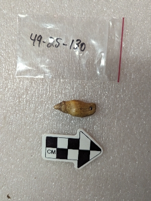
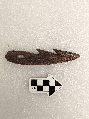
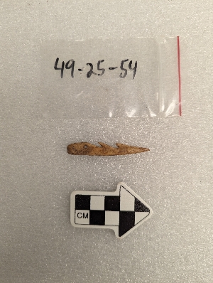
- arrowhead[6]
- awl[6]
- barb[6]
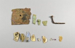
- bead[3]
- bird beak[1]
- bird bone[2]
- blade[3]
- blade fragment[4]
- block[1]
- bone[29]
- bone fragment[12]
- bone splinter[2]
- bone strip[4]
- boulder chip[4]
- bowl fragment[1]
- butt[1]
- carving[1]
- chert[2]
- china fragments[1]
- chip[3]
- chisel[8]
- chisel blade[1]
- clam shell[1]
- core[3]
- cup[4]
- cup fragment[1]
- dagger[1]
- dagger point[1]
- dart[1]
- disc[3]
- disc bead[3]
- drill[1]
- drinking tube[1]
- flake[8]
- flint[1]
- gaff hook barb[4]
- glass fragment[1]
- greenstone[1]
- grinding slab[1]
- hammer stone[1]
- hammerstone[12]
- hapoon head tip[1]
- harpoon head[16]
- knife[4]
- labret[3]
- lamp[2]
- lamp fragment[2]
- mussel shell[1]
- nose pin[1]
- object[4]
- paint[1]
- paint stone[18]
- pebble[3]
- pendant[7]
- pendant amulet[1]
- pestle[2]
- pestle fragment[1]
- pick[1]
- pin[25]
- pin fragment[1]
- planing adze[1]
- planing adze blade[1]
- point[16]
- point fragment[2]
- pumice[1]
- red paint stone[3]
- ring bead[3]
- rod[1]
- rubbing stone[1]
- rubbing tool[74]
- sample[1]
- saw[4]
- saw fragment[1]
- scapula scraper[1]
- scraper[6]
- scraper fragment[1]
- slab[11]
- splinter[3]
- splitting adze[5]
- stone fragment[1]
- tablet[4]
- thimble[2]
- toggle harpoon head[3]
- tool[10]
- tooth ornament[1]
- tooth pendant[1]
- tube[2]
- tube bead[4]
- tube fragment[1]
- tumbler bead[1]
- ulu[1]
- ulu blade[1]
- ulu blade fragment[2]
- ulu fragment[1]
- whetstone[27]
- worked bone[8]
- admiralty island[3]
- alaska[449]
- chilkoot lake[3]
- daxatkanada[24]
- daxatkanada fort[346]
- diyaguna'et[9]
- excursion inlet[1]
- groundhog cove[1]
- knight island[33]
- kootznahoo inlet[387]
- lost river[9]
- lutak inlet[3]
- lynn canal[3]
- mole harbor[2]
- pillsbury point[29]
- united states of america[448]
- yakutat bay[42]
- hoonah[1]
- prehistoric tlingit[3]
- taka tlingit[2]
- tlingit[6]
- yakutat (culture)[42]
- arctic culture area[449]
- 0'3'3" n of sw corner of square[1]
- 1'2" e and 3'2" n of sw corner of square[1]
- 1-s 12-18" in dark midden with large chitons[1]
- 1-s 6-12" below moss. total depth 9-15"[1]
- 1-s 6-12" midden just above guano[1]
- 1-s 6-12'' below moss.[1]
- 1-t 12-18"[1]
- 1-t 12-19" just above guano[1]
- 1-t 24-30" dark midden fill of "pit"[1]
- 1-t black midden fill in pit below guano, 17-27"[1]
- 1-v 12"-18" in midden, above orange subsoil.[1]
- 1s 6-12" midden just above guano[2]
- 2'8" e and 4'8" n from sw corner[1]
- 2'9" e and 4'3" n of sw corner of square[1]
- 2-e approx 6"[1]
- 2-e approx. 6"[1]
- 2-s 6-12"[1]
- 2-t 24" in midden under large boulder in depression[1]
- 2-t in guano-like light brown layer under bark layer, s. of hearth pit. total depth 16", 11" below moss.[1]
- 2-t total depth 16", 11" below moss. within brown bark layer lining hearth pit. part of stone paving[1]
- 22 1/2" depth partly under large rock at 13" nw corner of o-u[1]
- 2s - lying on surface of yellow clay, at bottom of midden[1]
- 2s 0-6"[2]
- 2s lying on surface of yellow clay, below midden[1]
- 2t 0-6" below moss. total depth 4-10"[1]
- 2t surface of light brown midden below charcoal and bark layer in hearthpit. 10" below moss. total depth 17" 16" e and 29" s of nw corner[1]
- 2t. 16" found near 240 in depression lining the pit[1]
- 3" e and 3'5" n of sw corner of square[1]
- 4'2" e and 2' north of sw corner of square[1]
- 4'2" e and 7" n of sw corner of square at one edge of hearth #2[1]
- 4'2" n of sw corner[1]
- a2e 6-12"[9]
- a2e depth 3"[2]
- b1e 0-6"[6]
- b1e 6-12"[3]
- beach[3]
- bottom layer 21-27 inches[3]
- c1e 0-6"[5]
- c1w 0-6"[2]
- c2e 12-18"[9]
- c2e 18-24"[4]
- c2e 6-12"[13]
- c2e depth 4"[2]
- c3e below 18"[2]
- d1e 0-6"[3]
- d1w 0-6"[3]
- d1w 12-18"[3]
- d1w 6-12"[4]
- d1w 6-12" in bark layer[2]
- d2e 6-12"[10]
- d2e depth 5"[2]
- d2e depth 6"[2]
- e1e 12-18"[7]
- e1e 18-24"[3]
- e1e 6-12"[7]
- e1w 0-6"[3]
- e1w 6-12"[2]
- e2e 0-6"[8]
- e2e 12-18"[7]
- e2e 18-24"[4]
- e2e 6-12"[2]
- e3e 0-6"[5]
- e3e 12-18"[3]
- f1e 12-18"[2]
- f1e 18-24"[4]
- f1e 18-24" dark compact midden below loose shells e 1/2 of square[2]
- f1e 30-40" dark forest humus and gray soil-above pink subsoil[2]
- f1e 6-12"[6]
- f1w 0-6"[2]
- f1w 10-12" midden[2]
- f1w 6-12"[5]
- f2e 0-6"[6]
- f2e 12-18"[5]
- f2e 18-24"[4]
- f2e 24-30"[8]
- f2e 6-12"[3]
- f3e 12-18"[2]
- fe3 0-6"[2]
- g1w 12-18"[3]
- g2e 0-6"[3]
- g2e 12-18"[2]
- g2e 18-24"[5]
- g2e 6-12"[2]
- h1w 6-12"[2]
- h2e 12-18"[5]
- h2e 6-12"[2]
- i.e.on surface of shelly layer[2]
- layers a-e[3]
- mound a, near house 5[8]
- mound b near house 1[3]
- mound b near house 1, 14-21 inches[6]
- mound b, about 14-16"[3]
- mound b, upper 10' in layer of fire-cracked rocks[10]
- o-t 18-24" black midden[4]
- o-t 6-12"[3]
- o-t 6-12" black midden[2]
- o-u 18-24" black midden[4]
- square b, a little over 12" in layer c[2]
- square d, layer d, 12-18"[2]
- square e 12-18"[2]
- animal bone[15]
- antler[4]
- argillite[1]
- basalt[2]
- bear bone[5]
- bear tooth[3]
- beaver tooth[3]
- bird bone[29]
- bone[103]
- brass[1]
- chalcedony[1]
- chert[12]
- china[1]
- clam shell[1]
- claystone[6]
- copper[3]
- deer bone[1]
- diorite[4]
- flint[1]
- glass[1]
- greenstone[15]
- hematite[1]
- iron[3]
- jade[1]
- jet[1]
- limestone[6]
- marble (stone)[11]
- metal[1]
- micaceous slatey schist[2]
- mudstone[1]
- mussel shell[2]
- paint[1]
- phyllite[1]
- pumice[1]
- quartz[2]
- quartzite[1]
- sandstone[28]
- schist[12]
- sea lion tooth[1]
- sea otter tooth[3]
- shale[53]
- shell[1]
- slate[66]
- steatite[2]
- stone[26]
- talc[1]
- tooth[1]
- whale bone[14]
- whale bone shaver[1]
- wood[1]
- yellow ash[1]
1 - 30 of 449 Records

1 - 30 of 449 Records