Search Collections
- Object[1,101]
- no[1,101]
- american[1,101]
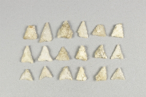
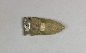
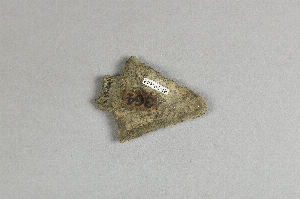
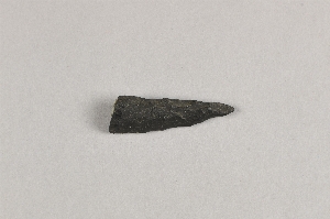
- arrowhead[1,101]
- knife[43]
- piercer[1]
- stone fragment[1]
- tool[1]
- allegheny county (pennsylvania)[2]
- atlantic county[7]
- beasley's point[1]
- belfast[1]
- bergen county[6]
- berks county[5]
- bethany[1]
- birchrunville[6]
- blennerhasset island[14]
- bristol (pennsylvania)[1]
- brookwood[1]
- brown county (ohio)[6]
- brown's farm[3]
- bucks county[75]
- burlington county[45]
- camden (new jersey)[1]
- camden county[1]
- cape henlopen[7]
- catawba (new jersey)[7]
- cayuga county[2]
- cecil county[3]
- chester county[29]
- chillicothe[11]
- claymont[4]
- clinton county[80]
- columbia (new york)[1]
- connecticut[4]
- crane's neck[3]
- dane county[1]
- delaware[19]
- delaware river[1]
- delaware water gap[228]
- diamond (ohio)[58]
- district of columbia[57]
- east orland[18]
- eastern united states[24]
- egypt mills[1]
- ellsworth[1]
- ewing and bragdon site[30]
- fairfield county[1]
- french creek[14]
- frenchman's bay[30]
- fry's run[3]
- fulton county (pennsylvania)[2]
- hammonasset[2]
- hancock county (maine)[49]
- herkimer county[1]
- illinois[5]
- indiana[1]
- kimberton region[14]
- lancaster county (pennsylvania)[13]
- lehigh county[2]
- limeport[1]
- lock haven[80]
- lumberton[36]
- maine[51]
- marquette county[180]
- marshall county[2]
- maryland[3]
- missouri[14]
- monroe county (pennsylvania)[208]
- montgomery county (pennsylvania)[3]
- moorestown[2]
- morgantown road[25]
- mount de chantal convent[16]
- naaman's creek[4]
- near easton[2]
- new castle county[4]
- new jersey[118]
- new york[6]
- northampton county[9]
- ohio[118]
- ohio county[2]
- ohio county (west virginia)[16]
- palmyra township[58]
- pennsylvania[477]
- philadelphia[3]
- philadelphia county[3]
- pittsburgh[2]
- point pleasant[5]
- portage county[58]
- raubsville[3]
- reading (pennsylvania)[5]
- region of palisades[6]
- riegelsville[30]
- ross county[11]
- sandy springs[8]
- schultz farm[3]
- schuylkill county[14]
- sheeders[14]
- suffolk county (long island)[3]
- sussex county (delaware)[7]
- united states of america[1,009]
- unites states of america[58]
- warren county (new jersey)[20]
- washington boro[13]
- west virginia[22]
- wheeling[16]
- wisconsin[181]
- wood county[14]
- late archaic[19]
- maritime archaic[18]
- modern[1]
- moorehead phase[18]
- algonquin[62]
- iroquois[26]
- late archaic[1]
- red paint people[18]
- northeast culture area[1,101]
- "riverside"[1]
- 13" deep, below 11" of cr. shell, on stratum of pebbles; on line 11, 1 1/2" from b.[1]
- 14" from 1[1]
- 19" from 5, 4 1/2" from b.[1]
- 8" deep in cr. shell and grass roots[1]
- 8" from a[1]
- banks of connecticut river[1]
- farm about 3 mi. above lock haven on south bank of west brnach of susquehanne river, surface.[1]
- flying moose lodge boys camp (est. 1921)[18]
- frank moran's farm, surface[4]
- from a shell-heap, near lewes[5]
- from brandywine (laubach) camp-site.[29]
- from roadside gutter[25]
- from rock shelter[14]
- from surface on flood plain of delaware river[1]
- hays stewart farm, operation ii, surface[9]
- in grass roots in disturbed area[1]
- in the sand stratum or at its base[1]
- jasper quarry[1]
- marshall county (?)[1]
- mckinney's farm, mouth of mcelhatten creek, south isde of west branch of susquehanna river, 4 mi. below lock haven. surface[2]
- monro farm, operation i, pit #26, depth 10 in[1]
- monro farm, operation i, pit #26, depth 7-8 in[1]
- monro farm, operation i, pit #26, depth 8 in[1]
- mound near rancocas creek; "bottom level"[1]
- mound near rancocas creek; "intermediate level"[1]
- mr. snider's garden[1]
- near lewes, from a shell heap[2]
- operation iii[1]
- operation iii, pit # e and f, -3[2]
- operation iii, pit # g, -1[1]
- pine station[4]
- pine station, quiggle farm, operation iii, pit no. e and f, -3. depth, surface to 14 in[1]
- pine station, quiggle farm, operation iii, pit no. g and h, -1 and -2. depth not recorded.[2]
- pine station, quiggle farm, operation iii, surface.[3]
- quiggle farm[4]
- shaw's farm, mouth of pine creek, below lock haen on west branch pf susquehanna river, surface[7]
- stratum of sand at its base.[1]
- surface[6]
- surface find[17]
- surface, neighborhood generally[4]
- van campen's island[2]
- vicinity, surface[39]
- village site and quarry[1]
- argillite[67]
- brass[1]
- carnelian[2]
- chalcedony[16]
- chert[34]
- copper[5]
- crystalline quartz[4]
- flint[83]
- glass[1]
- hornstone[7]
- jasper[64]
- milky quartz[9]
- quartz[6]
- quartzite[16]
- red jasper[11]
- rock crystal[1]
- shale[1]
- slate[2]
- stone[572]
- white quartz[3]
- yellow jasper[7]
- chipped[180]
- actual citation[362]
1 - 32 of 1,101 Records
1 - 32 of 1,101 Records