Search Collections
- Object[59]
- no[59]
- american[59]
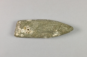
- splitting adze[59]
- alaska[59]
- anderson bay[2]
- anderson island[1]
- angiartunit[2]
- anvik[1]
- anvik point[1]
- anvik river[1]
- axlatuliq[7]
- bainbridge island[2]
- big cave[1]
- chenega island[9]
- chiktaruik[5]
- cook inlet[4]
- cordova bay[1]
- daxatkanada fort[3]
- esther passage[3]
- ewan bay[3]
- frank fox's place[2]
- galena bay[1]
- grass island[1]
- hawkins cut-off[1]
- hawkins island[5]
- hinchinbrook island[10]
- holy cross[2]
- kachemak bay[2]
- kaiyuh slough[1]
- khotol river[1]
- kimiklik village[3]
- knight island[1]
- kongoqrli[1]
- kootznahoo inlet[4]
- long bay[5]
- lower yukon river valley[4]
- middle yukon valley[1]
- montague island[8]
- mummy island[1]
- north america[5]
- nunakchuk[1]
- old fish camp[1]
- paddy bay[3]
- paingwashaq[1]
- palugvik village[5]
- pillsbury point[1]
- port graham[1]
- prince william sound[39]
- qeyagwik[6]
- reshanana creek[1]
- sheep bay[2]
- stockdale harbor[8]
- swanson creek[1]
- tozi river[1]
- united states of america[59]
- uqshitoq[1]
- yakutat bay[1]
- yukon island[2]
- eskimo[26]
- eyak[1]
- prehistoric eskimo[23]
- prehistoric indian[4]
- yakutat (culture)[1]
- 1st site on right lagoon[3]
- 2 ' below surface.[1]
- 2nd site on right lagoon[4]
- beach[4]
- beach below big cave.[1]
- beach.[4]
- found across bay from cannery at ingleumuq[1]
- found on beach[1]
- found on beach.[7]
- from the beach.[1]
- house 12[1]
- mound b, upper 10' in layer of fire-cracked rocks[1]
- north beach.[2]
- on top of island near se corner of garden plot, just ! of rocky ridge. driven into subsoil. butt 7" below surface and tip 14" below surface[1]
- small island inside anderson island[1]
- srtatum (ii or) iii, 2f, level 4[1]
- stratum i, 1f, 0-6"[1]
- stratum iii, 2g, level 5[1]
- turf layer, stratum i[1]
1 - 32 of 59 Records

1 - 32 of 59 Records