Search Collections
- Object[2,246]
- no[2,246]
- american[2,246]
- baked clay[1]
- bead[1]
- bone[2]
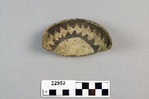
- bowl[16]
- clay[2]
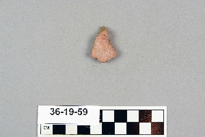
- clay fragment[1]
- dipper fragment[1]
- dipper handle[1]
- disc[5]
- figurine fragment[2]
- jar[1]
- lithic[1]
- metal fragment[1]
- mollusk shell[2]
- pendant[1]
- plaster fragment[1]
- polishing tool[1]
- pottery smoother[1]
- saucer[1]
- scraper[1]
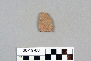
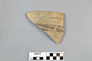
- sherd[2,246]
- strainer[2]
- alaska[61]
- alibates creek[10]
- arizona[546]
- bainbridge (pennsylvania)[13]
- balanced rock[83]
- bivens estate ranch[7]
- burlington county[11]
- cabarrus county[12]
- chaco canyon[15]
- charlton county[32]
- chatham county[14]
- chesser's island[32]
- citadel pueblo[25]
- clovis[9]
- colombia[25]
- colorado[330]
- corpus christi[19]
- cumberland county (new jersey)[17]
- delaware[10]
- delaware water gap[32]
- doro ana[96]
- duncan (arizona)[78]
- eastern arizona[10]
- eastern united states[23]
- eddy county[23]
- faraway ranch[10]
- florida[12]
- forbidden canyon[16]
- gaira[21]
- georgia[53]
- guatemala[8]
- irene mound site[14]
- kaiser's bottom[44]
- kayenta district[15]
- keetzeel[166]
- kentucky[9]
- la plata[11]
- lancaster county (pennsylvania)[21]
- little colorado area[24]
- little colorado culture area[127]
- little colorado region[53]
- live oak peninsula[27]
- lumberton[8]
- maljamar[15]
- mercer county[29]
- mesa verde district[25]
- mexico (central america)[12]
- mississippi[10]
- monroe county (pennsylvania)[39]
- nashville[9]
- navaho mountain[201]
- navajo reservation[330]
- neal[12]
- near alamogordo[84]
- near carlsbad[13]
- near la luz[19]
- new jersey[62]
- new mexico[523]
- north carolina[75]
- northeast arizona[53]
- nueces county[22]
- okefinokee swamp[32]
- otero county[103]
- owl house[108]
- pecos[8]
- pennsylvania[74]
- polard lake[10]
- red house ruin[17]
- rockport[19]
- rowan county[52]
- salt springs[9]
- saltville[18]
- san juan area[37]
- san juan culture area[77]
- second jernada site[10]
- silver springs valley[10]
- site 10[10]
- site 2[24]
- slaughter creek[10]
- smith creek[9]
- smyth county (virginia)[18]
- snaketown[21]
- southeast arizona[10]
- southwest united states[9]
- sussex county (delaware)[10]
- tecolote[53]
- tennessee[9]
- texas[71]
- trenton[29]
- tsebanahatci[108]
- tsegi canyon[33]
- tsegie river[10]
- unalakleet[55]
- united states of america[656]
- utah[376]
- venezuela[96]
- virginia[19]
- watrous[34]
- willard[29]
- wupatki pueblo[22]
- basketmaker iii[8]
- chubicuaro complex[1]
- historic[6]
- late pueblo iv[1]
- post basketmaker[1]
- prehistoric[48]
- protohistoric[1]
- pueblo i[8]
- pueblo ii[9]
- pueblo iii[4]
- pueblo iv[14]
- acoma[1]
- algonkian[10]
- algonquin[16]
- anasazi[101]
- arawak[6]
- basket maker[1]
- basket-maker[5]
- cherokee[1]
- cliff dweller[220]
- cliffdweller[303]
- eskimo[1]
- gila[24]
- hohokam[21]
- hopi[4]
- igneri[5]
- iroquois[20]
- keresan[2]
- maya[3]
- mound culture[1]
- pecos[1]
- prehistoric[14]
- prehistoric pueblo[121]
- protohistoric hopi[14]
- pueblo[234]
- pueblo iv[1]
- pume[96]
- taino[1]
- tairona[25]
- tarahumara[1]
- teotihuacan (mexico)[5]
- yaruro[95]
- zuni[3]
- "from gravels as deep in side of bank as 6' 5". trail cut along side in 1934, 5 ft. wide. pottery sherds in 17" deeper."[10]
- "mound slump" distubed ground.[2]
- "mound" - adobe walls[10]
- 0.25 mi. from b., below rock wall, on top of valley sediments[98]
- 1 1/2' - 2' under surface of rear of cave.[1]
- 100 yds. nne of section a, top of unconsolidated valley deposit[10]
- 16" below surface.[1]
- 1d, depth 22 in.[1]
- 1d, depth not over 22 in.[1]
- above profile c, surface find[4]
- above section b, surface find, near edge of bluff[4]
- anderson lake, about 15 mi. s.e. of clovis. from sand dune along edge of lake.[1]
- b: 2:1 and 2:2 (gladwin classification)[3]
- below surface/above main floor of burnt house[1]
- big wall[2]
- cave in sec. 13, block 121[1]
- cliff-house in side canyon of forbidden canyon[15]
- cliff-house in side of canyon[1]
- depth c. 15 in.[1]
- depth c. 18 in.[1]
- disturbed ground "mound slump".[2]
- found 15 miles above fort piere around peoria bottom[3]
- found in cave on side of mesa e.[1]
- found in cave on side of mesa east of mountain[1]
- four corners area[1]
- from a cave[1]
- from cave in upper rocky arroyo, west of carlsbad, n.m.[1]
- from cave in upper rocky arroyo, west of carlsbad, n.m. powers tank[1]
- from disturbed soil, mound slump[3]
- from disturbed soil. mound slump.[1]
- from gravel bank about 200 yards e. n.e. of kim, depth 18"[3]
- from gravel bank about 200 yards e. n.e. of kim, depth 25"[1]
- from gravel bank about 200 yards e. n.e. of kim, depth 26"[1]
- from gravel bank about 200 yards e. n.e. of kim, depth 32"[3]
- from gravel bank about 200 yards e. n.e. of kim, depth 38"[3]
- from roadside gutter[2]
- from undisturbed layer[1]
- from undisturbed layer.[2]
- gravel pit[1]
- house 1[2]
- house 109[3]
- house 111[4]
- house 113[2]
- house 115[2]
- house 119[3]
- house 120[30]
- house 3[9]
- jeditto[1]
- mescal pit in small canyon north of dark canyon near carlsbad, n.m.[1]
- midden ("kitchen trash deposit")[18]
- mound[3]
- mound 1 near chesser's house[1]
- mound 1, from undisturbed layer.[2]
- mound i, near chesser's house[1]
- mouth of cherry creek[1]
- ms. - s.1[1]
- n, 2:2 (gladwin classification)[2]
- n4.1, w3 - first layer under sod[1]
- north mesa[1]
- old camp #1[83]
- old camp #2[12]
- operation iii, pit # 200, section e -2[1]
- paint creek[1]
- pine station[1]
- pit house floor[1]
- prescott 2:19 (gladwin classification)[2]
- prescott 2:3, 2:23 (gladwin classification)[7]
- prescott, 2:19 (gladwin classification)[4]
- prescott, 2:4 (gladwin classification)[6]
- pueblo bonito[1]
- quiggle farm[1]
- rectangular pit house, 2d, depth 10 in.[1]
- rectangular pit house, 2d, depth 13 in.[1]
- rectangular pit house, 2d, depth 32-36 in. from below wall.[1]
- rectangular pit house, 2d, depth 43 in.[1]
- rectangular pit house, 2d, probably from humus.[1]
- river bank 1-1/2 mi north of pennsville[1]
- rossen's ranch near lawn[1]
- s 5.5, w 3 - in first (latest) floor and in gravel levels directly over first floor[2]
- s 6, w 4 - in first (latest) floor and in gravel levels directly over first floor[1]
- s 7, w 3.5 - in middle floor level[1]
- sand "blow out" 20-25 miles northeast of carlsbad; from surface[1]
- sand "blowout" 20-25 miles northeast of carlsbad[6]
- site 1[1]
- site 40 or 41[20]
- small cave on side of mesa[1]
- subsurface[1]
- surface[15]
- surface collection[80]
- surface find[12]
- surface find along cohansey creek[17]
- surface finds[66]
- surface near old digging[1]
- surface of gully in front of rim.[4]
- surface site 2 miles south of la luz[1]
- surface, rocky arroyo, near bates road west carlsbad, n.m.[1]
- surface.[1]
- test pit[2]
- test pit - at base of black and brown greasy level[2]
- vicinity of cape macao[1]
- animal head[1]
- arm[1]
- bird[1]
- hand[1]
- human head[1]
- animal bone[2]
- bark[96]
- bone[1]
- ceramic[5]
- clay[2,246]
- glaze[1]
- mica[1]
- mollusk shell[2]
- pigment[886]
- plaster[1]
- slip[1]
- stone[2]
- vegetal material[96]
- bidahochi polychrome[4]
- carved[1]
- chaco black-on-white[16]
- chipped[1]
- coiled[10]
- fired[3]
- great salt lake black-on-gray[1]
- incised[5]
- jeddito black-on-yellow[14]
- kayenta black-on-white[5]
- lino gray[1]
- little colorado black-on-red[1]
- little colorado black-on-white[25]
- mesa verde black-on-white[2]
- middle gila polychrome[3]
- painted[1]
- pecos polychrome[1]
- plain ware[2]
- polychrome[1]
- red ware[4]
- redware[1]
- roosevelt black-on-white[2]
- salado red[1]
- sherd[2]
- slipped[1]
- smoothed[1]
- st. johns polychrome[2]
- stamped[45]
- tusayan black-on-red[2]
- walnut black-on-white[1]
- actual citation[34]
- general reference[99]
1 - 32 of 2,246 Records