Search Collections
- Object[339]
- no[339]
- antler[5]
- bead[1]
- bodkin[1]
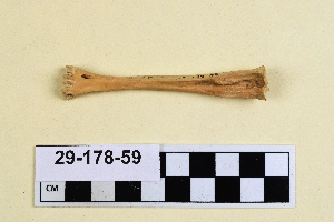
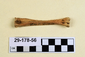
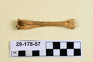
- bone[339]
- button[1]
- cast[1]
- ceramics[1]
- charcoal[2]
- china fragments[1]
- coin[1]
- copper[1]
- core[1]
- figurine[1]
- finger ring[1]
- flake[1]
- flint[1]
- fragment[2]
- gem[1]
- gold[1]
- hearth[2]
- horn[1]
- ice pick[1]
- ivory[17]
- jaw bone fragment[1]
- leather[1]
- lithic[10]
- mollusk shell[7]
- mounting[1]
- net[1]
- organic matter[2]
- paper[1]
- point[1]
- pottery[1]
- saw[1]
- shears[1]
- shell[1]
- sherd[14]
- sherds[3]
- soil[2]
- spoon[1]
- stone[2]
- teeth[1]
- tool[1]
- tooth[14]
- tube[1]
- turtle shell[1]
- weaving tool[1]
- whistle[1]
- wood[3]
- abri blanchard[1]
- ahyutaung[13]
- alaska[136]
- aleut village[1]
- aleutian islands[8]
- anderson bay[1]
- angiluk[1]
- antinoe[1]
- anvik point[1]
- asia[1]
- baq'ah valley[1]
- bavaria[1]
- belgium[1]
- beth shemesh[1]
- between san juan and colorado rivers[1]
- blackburn[2]
- blackburn slough[2]
- bohemia[30]
- bonasila[1]
- boswell bay[1]
- bramford pit[1]
- burma[27]
- canada[1]
- cape denbigh[16]
- cape nome[4]
- commune de chancelade[2]
- cook inlet[16]
- cottonwood creek (alaska)[1]
- czech republic[30]
- daxatkanada fort[11]
- dhiban[1]
- dinkha[13]
- dordogne[7]
- dutch harbor[1]
- egypt[1]
- england[1]
- europe[2]
- ewing and bragdon site[19]
- fairfield county[1]
- feru i[1]
- florida[1]
- fox farm[1]
- france[10]
- frenchman's bay[19]
- fury and hecla strait[1]
- gailenreuth cave[1]
- gravina bay[1]
- halibut cove[2]
- hancock county (maine)[19]
- hawkins island[10]
- hinchinbrook island[2]
- hostoun[30]
- iran[13]
- iraq[2]
- ishmailoff island[2]
- iyatayet[16]
- jordan[3]
- kachemak bay[15]
- kaiyuh slough[3]
- khotol river[3]
- kladno[30]
- knight island[25]
- kootznahoo inlet[15]
- la madeleine[5]
- lower yukon river valley[7]
- maine[19]
- mexico (central america)[3]
- mong pawn rock shelter[12]
- new mexico[13]
- nippur[2]
- north america[9]
- norton sound[16]
- old fish camp[2]
- old town[22]
- palu:tat[2]
- palugvik village[9]
- panama[18]
- peru[3]
- pillsbury point[4]
- pisco province[2]
- prince william sound[12]
- puntilla[2]
- raymonden[2]
- rio grande region[13]
- salmon lake[4]
- saltville[6]
- san juan drainage[3]
- seward peninsula[4]
- shan state[26]
- shemya island[8]
- sitio conte[17]
- smyth county (virginia)[6]
- southeastern utah[4]
- texas[2]
- unalakleet[4]
- united states of america[177]
- virginia[6]
- west beach[3]
- yakutat bay[25]
- yukon island[31]
- sitio conte[17]
- aleut[9]
- basket maker[1]
- cliff dweller[4]
- cocle[16]
- eskimo[31]
- indian[2]
- kachemak bay culture iii[5]
- kachemak bay culture sub-iii[1]
- magdalenian[8]
- modern indian[2]
- norton[16]
- paleolithic[1]
- plains indian[1]
- post russian[1]
- prehistoric eskimo[25]
- prehistoric indian[2]
- sioux[1]
- swiss lake dweller[1]
- tanaina[1]
- yakutat (culture)[3]
- #2[1]
- 10' 8" - 11' 5"[1]
- 10'2" - 10'7"[1]
- 103.13ns 103.15ew[1]
- 104.9ns 102.3es[1]
- 2 ' below surface.[1]
- 2 1/2 ' below surface.[1]
- 2 g, 4' - 4' 8", vi or vii[1]
- 2 g, surface - 1' 6", viii to x[2]
- 2 j[1]
- 2 l 6', ii? found with 290[1]
- 2d, 1' 6" - 2', vii or viii[1]
- 2d, 6" -1', viii (ix)[1]
- 2f, 3'6" - 4', viii (ix?)[1]
- 2g, 3'6", to 4', vii or viii[1]
- 2t surface of light brown midden below charcoal and bark layer in hearthpit. 10" below moss. total depth 17" 16" e and 29" s of nw corner[1]
- 3 j, 6" - 1'3"[1]
- 4 1/2 ' below surface.[1]
- 4 j[1]
- 4 k[2]
- 4 k, 12' 6" - 13', layer 1[1]
- 4'9" - 5'3"[1]
- 5 ' below surface.[2]
- 5'6" - 6'[1]
- 6'3" - 6'9"[1]
- 6'6" - 7'[1]
- b, surface to 9", ix[1]
- bottom layer 21-27 inches[1]
- bottom of bone shaft[1]
- c and d, 1' to 4'[1]
- chigurtaoq[1]
- d near surface[1]
- d, 1 '6" - 2', viii or ix[1]
- d, 3' - 3' 6", vii[1]
- e, 2' 6" - 2' 9", vii[1]
- e1e 6-12"[1]
- e3e 12-18"[1]
- e3e 6-12"[1]
- el valle[1]
- eusebio cubero quarry[1]
- f, 6' 6" - 7' 3", iii[3]
- f2e 12-18"[2]
- f2e 24-30"[1]
- g, 6' 6" - 7' 3", iii[2]
- g, 8' 6" - 9' 3", i-ii[1]
- g1e 12-18"[1]
- g2e 18-24"[1]
- hole 3[1]
- house 11[3]
- house 12[2]
- house 13, floor[1]
- house 2[1]
- house 2 floor[1]
- house 2 possible entrance[1]
- house 285[1]
- house 3[3]
- house 3 ' below surface.[1]
- house 8, just above floor of burned structure in subsurface pit #24, depth 46"[1]
- j[1]
- k, 7' - 7' 6", layer 3, refill in house[1]
- layer 10 ft. below surface.[1]
- layer 4 (?)[1]
- layer 5a?[1]
- layer 6[1]
- layer 6 or 5-c[1]
- layer 7[1]
- layer 8[1]
- layers a-e[2]
- midden ("kitchen trash deposit")[6]
- midden.[2]
- mound a, upper level, depth 13"[1]
- mound a, upper level, depth 16"[1]
- mound b[1]
- mound b near house 1[1]
- mound b, upper level, depth 14"[1]
- mound b, upper level, depth 15"[1]
- mound b, lower level, depth 29"[1]
- mound b, lower level. small cache house, subsurface pit 36[1]
- mound b, subsurface pit 8, level a[1]
- mound b, upper 10' in layer of fire-cracked rocks[2]
- mound b, upper level, depth 13", shell stratum[2]
- mound b, upper level, depth 14"[1]
- mound b, upper level, depth 14", shell layer[1]
- mound b, upper level, depth 18-24"[1]
- mound b, upper level, depth 25"[1]
- mound b, upper level, depth 6-12"[2]
- mound b, upper level, depth 8"[2]
- mound d, lower level, depth 18"[1]
- mound d, lower level, sw corner of sq. in shell midden layer[1]
- n 4, w 4 - in floor[1]
- near kunlon- vic. of taunggyi[12]
- near kunlon; vic. of taunggyi[1]
- o-t 6-12"[1]
- o-u 18-24" black midden[1]
- pit 3[1]
- rubbish heap--west point.[1]
- s 6.5, w 2 - floor[3]
- square d, layer d, 12-18"[2]
- tr. 2, b 11[11]
- trench 2, burial 19, from fill above grave[2]
1 - 32 of 339 Records