Search Collections
- Object[2,694]
- american[2,298]
- asian[1]
- european[86]
- near eastern[309]
- adze[2]
- arrow point[1]
- arrowhead[54]
- awl[2]
- axe[1]
- axe head[1]
- bannerstone[1]
- bead[1]
- biface[2]
- blade[329]
- blade fragment[36]
- blades[1]
- cast[1]
- celt[10]
- chip[6]
- core[11]
- cores[1]
- drill[52]
- drills[1]
- end scraper[5]
- engraver (engraving tool)[5]
- flake[114]
- flake knife[12]
- flakes[3]
- flint[15]
- flint fragment[1]
- gorget[2]
- graver[1]
- gunflint[6]
- hand axe[1]
- hand chopper[1]
- hoe[2]
- hook[1]
- implement[36]
- implements[1]
- javelin head[1]
- knife[497]
- knives[2]
- lithic[46]
- lithics[36]
- object[1]
- paint cup[1]
- pebble[3]
- perforator[2]
- point[247]
- point fragment[1]
- points[1]
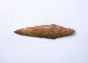
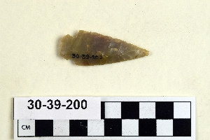
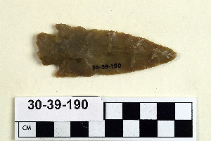
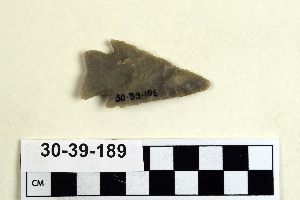
- projectile point[1,035]
- projectile point fragment[1]
- reject[3]
- saw[2]
- scraper[232]
- scraper fragment[5]
- scraper knife[6]
- side scraper[9]
- spade[3]
- spear point[3]
- spearhead[28]
- specimen[3]
- stem[1]
- stone[1]
- tool[4]
- tools[2]
- abilene[7]
- adams county (mississippi)[12]
- alaska[8]
- alibates creek[23]
- anderson lake[33]
- beck forest lake[14]
- belgium[83]
- berks county[37]
- beth shean[308]
- big timber creek[9]
- bivens estate ranch[23]
- blowout mountain[14]
- boone county[14]
- bucks county[19]
- burke county[12]
- california (state)[38]
- canadian river[21]
- chickies[8]
- chillicothe[77]
- clovis[53]
- cumberland county (tennessee)[20]
- curry county[12]
- diamond (ohio)[343]
- east orland[33]
- east tennessee[66]
- eastern pennsylvania[14]
- eastern united states[11]
- eddy county[7]
- elgin[184]
- elm creek[8]
- ewing and bragdon site[233]
- flint ridge[18]
- florida[9]
- floyd county (georgia)[20]
- fly site[7]
- frenchman's bay[233]
- fresno county[10]
- georgia[45]
- gloucester county[13]
- gordon county[10]
- grassy cove[19]
- gravel pit[23]
- green river[12]
- guadalupe (california)[7]
- gulf of mexico[7]
- hancock county (maine)[265]
- illinois[12]
- israel[308]
- kentucky[47]
- lancaster county (pennsylvania)[23]
- lehigh county[11]
- licking county[14]
- maine[266]
- mammoth cave[20]
- maryland[8]
- mercer county[12]
- mississippi[19]
- monmouth county[6]
- montgomery county (tennessee)[29]
- natchez (mississippi)[8]
- near abilene[20]
- near clovis[17]
- near eden[10]
- near taos[6]
- new jersey[109]
- new mexico[147]
- new york[10]
- north america[29]
- north carolina[17]
- nueces county[9]
- ohio[594]
- ohio river valley[6]
- padre island[7]
- palmyra township[343]
- pennsylvania[467]
- pennsylvania region[29]
- pimatella ranch[8]
- portage county[345]
- pricetown[13]
- railroad mountain[8]
- rockport[9]
- rome (georgia)[19]
- ross county[92]
- san nicolas island[7]
- santa barbara county[8]
- shell bluff[12]
- site 2[10]
- site 5[8]
- site 8[19]
- spiennes[83]
- sweetwater county[10]
- tennessee[56]
- texas[267]
- tranquillity[10]
- tranquillity site[10]
- trenton[12]
- trouille valley[47]
- united states of america[1,745]
- unites states of america[345]
- wyoming[26]
- finley site[5]
- byzantine[12]
- central california phase[10]
- chalcolithic[114]
- early arabic[12]
- early bronze i[74]
- early bronze ii[93]
- early bronze iii[50]
- early bronze iv[1]
- early horizon[10]
- historic[4]
- iron age ia[5]
- iron age ib[5]
- kachemak bay culture i[1]
- late archaic[33]
- late bronze iib[4]
- late woodland period[2]
- maritime archaic[33]
- middle bronze i[1]
- middle bronze iib[2]
- middle bronze iic[2]
- middle horizon[10]
- modern[1]
- moorehead phase[33]
- neolithic[108]
- neolithic period[47]
- paleoindian[5]
- prehistoric[3]
- basket maker[1]
- basketmaker[1]
- cherokee[14]
- cliff dweller[3]
- cody cultural complex[5]
- eskimo[7]
- hopewell[9]
- indian[1]
- iroquois[4]
- native american[3]
- neolithic[85]
- prehistoric eskimo[1]
- pueblo[1]
- red paint people[33]
- arctic culture area[12]
- california culture area[45]
- central american[1]
- great plains culture area[35]
- north american culture area[22]
- northeast culture area[1,524]
- northeast culture area [1]
- northwest coast culture area[30]
- plains culture area[5]
- southeast culture area[237]
- southwest culture area[402]
- subarctic culture area[3]
- "johnny-behind-the-deuce cave"[4]
- "mound" - adobe walls[3]
- 1 1/2" of ashes below, heap 24" deep[1]
- 1 1/2" of beach gravel and fire dirt[1]
- 10 1/2" deep below 6 1/2" of ploughed area[1]
- 10 1/2" deep in cr. shell[1]
- 10 3/4" from 3[1]
- 10" from 8[1]
- 11" deep in whole and cr. shell[1]
- 11" deep, 8" down in cr. shell[1]
- 11" from a[1]
- 11" from b.[1]
- 12" deep in cr. shell[1]
- 12" from 14[1]
- 13 1/2" deep, in cr. shell and fire dirt;[1]
- 13 1/2" from 3[1]
- 13" deep under 10" of whole and cr. shell, in narrow layer of fire dirt[1]
- 13" deep, below 11" of cr. shell, on stratum of pebbles; on line 11, 1 1/2" from b.[1]
- 13" down in 16" band of shell over fire pit[1]
- 13" from c. 17" from 5[1]
- 14" deep, heap 28" deep; 25" from c, 27" from 3[1]
- 14" from 1[1]
- 14" from 7, 15" from c.[1]
- 14" from a[1]
- 14" from a.[1]
- 15 1/2 from 7[1]
- 15" deep in cr. shell[1]
- 15" deep in cr. shell and fire dirt[1]
- 15" deep in finely cr. shells extending 20" down from top[1]
- 16 1/2" deep on top of ash and beach gravel and fine shell 5" deep[1]
- 16 1/2" from c, 19" from 1.[1]
- 16" from 3, 33 1/2" from c.[1]
- 17 1/2" deep[1]
- 17 3/4" from c. on line 4[1]
- 17" deep in cr. shell area[1]
- 17" deep in humus, beach gravel and fire dirt and shell, on top of basic clay[1]
- 17" deep in whole and cr. shell 5 3/4" thick at bottom of heap.[1]
- 17" deep, under ploughed area[1]
- 17" from c, 4" from 14[1]
- 17" from d, 2" from 6[1]
- 18 1/2" from 5[1]
- 18 1/4" from c.[1]
- 18 1/4" from c. 3 1/2" from 3[1]
- 18" deep below 10" of shell[1]
- 18" deep in 7 3/4" layer of b. gravel[1]
- 18" from d[1]
- 19" deep in whole and cr. shell to within 2 1/2" from bottom[1]
- 19" from 5, 4 1/2" from b.[1]
- 19" from c. 14 1/2" from 6[1]
- 1a[1]
- 1a, depth 22 in.[1]
- 2 1/2" down in 5 1/2" of cr. shell, ploughed[1]
- 2 1/2" from 2[1]
- 2 1/2" from c.[1]
- 2 3/4" from 12.[1]
- 2 mi. w. of gravel pit near clovis, n.m.[3]
- 2" from b, 13" from 4[1]
- 2" from bottom of whole and cr. shell and fire dirt[1]
- 2" of fire dirt, in 3" layer of beach pebble and fire dirt[1]
- 2" under a 6"" band of beach gravel[1]
- 20 1/2" deep[1]
- 20 1/2" deep in fine cr. shell all way down[1]
- 20 1/2" from 14.[1]
- 20" from c, 4 1/4" from 4[1]
- 21 1/2" from c. 15" from 7[1]
- 21" deep down in band of cr. and whole shell[1]
- 21" deep in cr. shell from top to bottom[1]
- 21" down in 16" band of shell over fire pit[1]
- 22 1/2" deep in cr. shell and fire dirt,[1]
- 22" deep in 1" of beach pebble below 2" of black ash at bottom of heap[1]
- 22" deep in cr. shell and fire dirt at bottom of heap[1]
- 22" deep, under 17" of cr. shell, and 1" of b. gravel, in 1 1/2" of fine cr. shell and fire dirt[1]
- 22" down in stratus of fire dirt, fire, beach gravel, and shell[1]
- 22" from b, 6" from 6[1]
- 23" deep in ash[1]
- anderson lake, about 15 mi. s.e. of clovis, n.m.[13]
- basin site[7]
- bison kill/processing area[5]
- camp site[2]
- cave[2]
- creek bed of elm creek 7.5 mi. south of abilene[5]
- first terrace surface[6]
- flying moose lodge boys camp (est. 1921)[33]
- from "blow-outs" near finley site, near eden[4]
- from bank along clear fork of brazos river about 2.5 mi. east of hawley, texas, found 20 ft. below surface, just below level of a large mammoth tusk.[2]
- from lake 3 mi. w. of gravel pit near clovis, n.m.[3]
- from lake bank 1 mi. s.e. of gravel pit near clovis, n.m.[2]
- from old lake west of gravel pit about 18 mi. s.w. of clovis[4]
- from roadside gutter[2]
- gravel pit west dump, surface[3]
- killpecker dune field[5]
- region around rockport[10]
- sand dune surface site near nugent[2]
- shores of delaware river at morrisville, pa., and trenton, n.j.[3]
- sunshine valley[2]
- surface[28]
- surface around gravel pit near clovis, n.m.[2]
- surface site[14]
- walled cave rocky arroyo seep 50-60 miles west of carlsbad[2]
- workshop on gravel terrace, northeast of farson[3]
1 - 32 of 2,694 Records