Search Collections
- Object[415]
- no[415]
- american[415]
- chisel[4]
- drill[4]
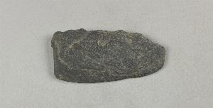
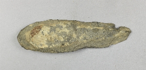
- fragment[5]
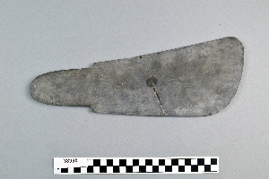
- knife[415]
- lance blade[1]
- lance head[2]
- savik[1]
- scraper[4]
- ulo[107]
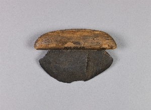
- ulu[73]
- ulu fragment[9]
- alaska[379]
- arizona[1]
- bartlett shellheep[1]
- berks county[1]
- big diomede island[1]
- british america[1]
- british columbia[2]
- burlington county[3]
- canada[2]
- cape denbigh[33]
- connecticut[1]
- cook inlet[13]
- cottonwood creek (alaska)[1]
- daxatkanada[1]
- delaware[1]
- diyaguna'et[1]
- edgefield county[3]
- halibut cove[7]
- hampton falls[2]
- hawkins island[3]
- iredell county[3]
- ishmailoff island[7]
- iyatayet[33]
- kachemak bay[13]
- knight island[8]
- kootznahoo inlet[1]
- labrador[1]
- lancaster county (pennsylvania)[2]
- locust grove[1]
- lost river[1]
- lumberton[1]
- marshall county[2]
- mercer county[3]
- moores island[1]
- new hampshire[2]
- new jersey[6]
- north carolina[3]
- northern alaska[3]
- norton sound[33]
- nunivak island[1]
- nuwuk[5]
- ohio[1]
- ohio county[2]
- okiaby[1]
- old town[8]
- palugvik village[3]
- pennsylvania[9]
- point barrow[4]
- point barrow region[28]
- point hope[257]
- pricetown[1]
- prince william sound[3]
- siberia[1]
- south carolina[3]
- susquehanna valley[2]
- trenton[3]
- unalakleet[2]
- united states of america[351]
- utkiavik[20]
- vancouver island[2]
- wainwright[1]
- walukpant[3]
- west beach[1]
- west virginia[2]
- wunqra[6]
- yakutat bay[9]
- yukon island[27]
- eskimo[151]
- inuit[1]
- kachemak bay culture iii[13]
- kachemak bay culture sub-iii[2]
- norton[18]
- nukleet[15]
- prehistoric eskimo[187]
- thule[4]
- yakutat (culture)[1]
- 10'-11'[1]
- 2 d, 4' 8" - 5' 4", vii[1]
- 2 f, 2' 6" - viii (ix?)[1]
- 2 f, 4' - 4' 6", viii (ix?)[1]
- 2 j[1]
- 2'6" - 3'[1]
- 3 h[1]
- 3 j[1]
- 3 j, surface (under turf)[1]
- 3 l 6', v[1]
- 3 or 4 h[1]
- 3'6" - 4'[1]
- 4 h[1]
- 4 j[1]
- 4 k, 2'3" - 2'9"[1]
- 5' - 5'6"[1]
- 6' - 6'6"[1]
- 7'3" - 8'[1]
- b, 1' 9" - 2', ix[1]
- bank[1]
- banks of connecticut river[1]
- d, 3' - 3' 6", vii[1]
- e 2' 6" - 2' 9", vii[1]
- e3e 12-18"[1]
- east point, midden on spit[1]
- f, 1' 6" - 2', viii[1]
- g, 9' 6" - 10', i[2]
- hole ii[2]
- house 3[1]
- house 8[1]
- ip house[1]
- iy[1]
- iya 2 4-6[1]
- iyeb 6-10[1]
- iyed[1]
- iyed u[1]
- iyem lower[2]
- iyem up[2]
- iyh-2[4]
- iyh-2gen[2]
- iyh-3[2]
- iyh-4 up[1]
- iyh1-t[2]
- iyhi-t[1]
- iyk-24[1]
- iypbup[1]
- iypd up[1]
- iyr 1-2[2]
- iyz 5[3]
- iyz 5 mid[1]
- iyz-1 mid[1]
- iyz-1 up[1]
- iyz5[1]
- k 1' 6"-2'[3]
- l. surface - 1' 6"[2]
- laurie's mill pond[1]
- layer (6?) or 7[1]
- layer 5-b[1]
- layer 5-c[1]
- layer 5a[1]
- layer 6[1]
- layer 6 or 7[1]
- layer 7[1]
- layer 7?[3]
- layer 8[1]
- layer 8, 7? or 6[3]
- layer 9?[1]
- m. 1' 6"- 2'[1]
- mound b[4]
- mound c[3]
- near yakutat. from lower level of midden. c. 24"[1]
- pit 3[1]
- s 5, e 0 - in tip level which merges with latest floor level in northern part of house[1]
- stratum iii, 2c, level 7[1]
- stratum iii, 2e, level 7[1]
- chipped[13]

1 - 32 of 415 Records