Search Collections
- Object[159]
- no[159]
- american[159]
- charm[1]
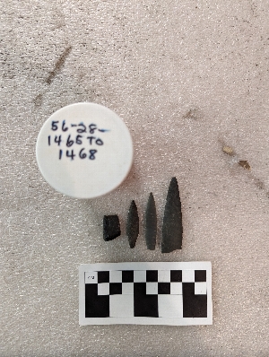
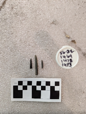
- projectile point[159]
- alaska[159]
- cape darby[2]
- cape denbigh[77]
- cape nome[22]
- iyatayet[77]
- knight island[29]
- madjujuinuk site[2]
- northern alaska[1]
- northwest alaska[3]
- norton sound[79]
- nuwuk[1]
- old town[29]
- point barrow[3]
- point barrow region[2]
- point belcher[2]
- point hope[5]
- unalakleet[4]
- united states of america[130]
- utkiavik[2]
- wainwright[1]
- yakutat bay[29]
- yukon island[1]
- historic[1]
- old town i[7]
- old town ii[14]
- old town iii[7]
- denbigh flint complex[9]
- eskimo[47]
- norton[68]
- paleo-eskimo[2]
- cut a[7]
- drainage ditch[6]
- gray sandy midden, possibly fill of subsurface pit a.[2]
- house 11[1]
- house 120[1]
- house 14[1]
- house 18[1]
- house 19[10]
- house 2[2]
- house 268[1]
- house 285[1]
- house 3[1]
- house 7(?), depth 12"[1]
- house 7, depth 9" dark gray sandy midden[1]
- house 8, box in center, pit 24[2]
- house 9, floor, between wall and floor[1]
- house 9, just above floor, depth 21", tan sandy midden above rock[1]
- house 9, pit outside house, tan sandy midden[1]
- in humas and thermal fractured rock[1]
- iy[1]
- iy hi uf-3[1]
- iya[1]
- iya3 1-4[1]
- iya32[1]
- iyaa[1]
- iyd[1]
- iye[3]
- iye gen[1]
- iye ll[2]
- iye5[1]
- iyeb[1]
- iyeb 1-5[1]
- iyeb 11-13[1]
- iyeb 4-10[1]
- iyed[1]
- iyed 6-9[1]
- iyem[3]
- iyem upper[1]
- iyh-7[1]
- iyh-7b[2]
- iyh1 uf4[1]
- iyh3[1]
- iyh4[1]
- iyh7 upt[1]
- iyhi hf2[1]
- iyhi uf3[1]
- iyhi-c uf 3,4[1]
- iyhi-d upi-3[1]
- iyhi-t uf gen[1]
- iyk-25[1]
- iyk-55[1]
- iyk-56[1]
- iym[7]
- iyo[1]
- iyp misc[1]
- iypa[2]
- iypc[2]
- iypd(?)[1]
- iype m[1]
- iype-1 lm[1]
- iype-2 lm[1]
- iype-5 lm[1]
- iype-5 um[1]
- iype-5 upm[1]
- iype-6 lm[1]
- iype-7 upm[1]
- iypf 1m[1]
- iyphm[1]
- iypm l[1]
- iyr 1,2[1]
- iyz5[9]
- mad[2]
- mound a, upper level, depth 13" gray sand with bark, thermal-fractured rock.[1]
- mound a, upper level, depth 6", in mussel shells[1]
- mound b (?), backfill[1]
- mound b, lower level, depth 19", shell layer[1]
- mound b, lower level, depth 24-30", brown sandy midden[1]
- mound b, lower level, depth 32", black sandy midden[1]
- mound b, lower level, depth 40" sub-surface pit 14[1]
- mound b, lower level, depth:25"[2]
- mound b, lower level, depth:45"[1]
- mound b, upper level, depth 14",[1]
- mound b, upper level, depth 2"[1]
- mound b, upper level, depth 23", gray sandy midden[1]
- mound b, upper level, depth:14"[1]
- mound b, upper level, depth:6"[1]
- mound c, upper level, depth 12"[1]
- mound c, upper level, house 7, depth 22" gray sandy midden[1]
- mound d, depth 8", dark rocky midden[1]
- mound d, lower level, depth 23", shell midden layer[1]
- mound d, upper level, depth 19", dark rocky midden[1]
- n 0.5, w 1 - in compacted gravel level which is probably a continuation of hosue wall[1]
- n 2.0, w 0.75 - in level which is a continuation of house wall.[1]
- s 7, w 3 - in land above upper level which merges with first floor[1]
- storage house, depth 33"[1]
- storage house fill, subsurface pit 15, in box, depth 39"[1]
- actual citation[22]
1 - 32 of 159 Records

1 - 32 of 159 Records