Search Collections
- Object[124]
- no[124]
- abilene[3]
- adams county (mississippi)[8]
- adams mills[1]
- alaska[20]
- albany county[1]
- anderson canyon[1]
- antelope creek[2]
- aransas county[1]
- australia[12]
- ballas[3]
- bingaman plantation[1]
- blowout mountain[1]
- california (state)[1]
- canadian river[6]
- cape henlopen[1]
- chickies[1]
- colorado[1]
- concordia parish[5]
- cook inlet[3]
- cottonwood creek (alaska)[2]
- cottonwood creek (texas)[1]
- culberson county[1]
- daxatkanada fort[1]
- delaware[1]
- diyaguna'et[1]
- dunbar plantation[1]
- east tennessee[1]
- eddy county[1]
- egypt[3]
- elm creek[3]
- europe[1]
- ferguson plantation[1]
- ferriday plantation[4]
- florida[1]
- fort rosalie[2]
- germany[1]
- gillespie plantation[2]
- gould ruin[3]
- guadalupe mountains[1]
- handley ranch[3]
- honshu[6]
- illinois[3]
- indian hill[5]
- italy[1]
- japan[6]
- jefferson county (mississippi)[1]
- kachemak bay[3]
- kanagawa prefecture[6]
- kibby plantation[1]
- kings ruins[1]
- knight island[11]
- kootznahoo inlet[1]
- lancaster county (pennsylvania)[1]
- landergin[7]
- lendsey farm[4]
- logan (new mexico)[2]
- lost river[1]
- loudonville[1]
- louisiana[7]
- marshall county[1]
- meigs county (ohio)[2]
- mississippi[11]
- naqada[3]
- near abilene[12]
- near carlsbad[1]
- new mexico[3]
- new york[1]
- northwestern united states[1]
- ohio[3]
- ohio county[1]
- old town[11]
- pennsylvania[2]
- perugia[1]
- point barrow region[4]
- pulaski county[1]
- quay county[2]
- railey plantation[2]
- richmond (australia)[12]
- riddell plantation[1]
- rock retreat[1]
- rugen[1]
- san miguel island[1]
- shade river[1]
- southeast tennessee[1]
- southeastern australia[12]
- southern illinois[1]
- st. catherine[1]
- sussex county (delaware)[1]
- tallahassee[1]
- tensas mound[1]
- tensas parish[1]
- texas[40]
- united states of america[94]
- utkiavik[4]
- victoria (australia)[12]
- west beach[1]
- wolf creek[3]
- yakutat bay[12]
- yokohama[6]
- yukon island[2]
- jomon[6]
- neolithic[1]
- paleolithic, japan[6]
- yayoi[6]
- 0.75 mi. beyond bridge[2]
- 2 ' below surface.[2]
- 3 m 8', ii[1]
- 5 h[1]
- 5'6" - 6'[1]
- c2e 12-18"[1]
- elm creek surface site[2]
- layer 6 (7?)[1]
- mesa site[2]
- mound[1]
- mound b[7]
- mound c[1]
- mound d[3]
- near mouth of elm creek[1]
- near yakutat. from lower level of midden. c. 24"[1]
- paint creek[1]
- pit 3[1]
- shell heap[1]
- site 48 (dewitt farm)[1]
- surface[4]
- surface of cave.[1]
- surface site[5]
- surface site in cotton field 1 mi. e. of lawn[2]
- surface site in cotton field mile e. of lawn[1]
- surface site near abilene[1]
- bird bone[1]
- bone[5]
- chalcedony[9]
- chert[4]
- deer bone[1]
- flint[43]
- greenstone[2]
- igneous rock[2]
- jasper[19]
- metasediment[1]
- obsidian[1]
- quartz[1]
- quartzite[1]
- sandstone[1]
- schist[2]
- slate[4]
- stone[31]
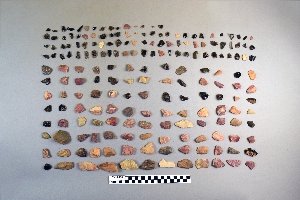
1 - 32 of 124 Records